Showing posts with label Northern Samar. Show all posts

Calbayog City: Gateway to Samar and Northern Samar

Calbayog Samar

Calbayog is a city in the province of Samar and is one of the commercial trade centers of Eastern Visayas region. It located on the north-western coast of the island of Samar, next to the border separating the provinces of Samar and Northern Samar. Waray is the major language spoken in Calbayog City.

Basic Waray Phrases for Travel

Buyogan Festival

Waray-Waray, or Waray in short, is spoken in the provinces of Leyte, Samar, Eastern Samar, Northern Samar and Biliran. When traveling to these provinces in Eastern Visayas, it really helps a lot if you will learn some basic Waray phrases. When riding the jeepney or tricycle, buying food or pasalubong, or simply greeting your local friends, knowledge of some Waray phrases will help you get around easier and will surely make your visit more fun. Here is a list of useful Waray phrases essential for tourists and travelers.

Biri: Town Proper


Biri Town Proper

See complete photo album: Biri, N. Samar: Downtown Biri (August 1, 2011)

Biri: Magsapad Rock Formation


Magsapad Rock Formation

See complete photo album: Biri, N. Samar: Magsapad Rock Formation (August 1, 2011)

Biri: Magasang Rock Formation


BIRI, Northern Samar - Magasang Rock Formation


See complete photo albums:
Biri, N. Samar: Magasang Rock Formation - Part 1 (August 1, 2011)
Biri, N. Samar: Magasang Rock Formation - Part 2 (August 1, 2011)


Biri: Going to Magasang & Magsapad Rock Formations

BIRI, Northern Samar - Among the six rock formations of Biri, Magasang (left) and Magsapad (right) are the most famous, the most photographed and the most accessible (relatively). While the Biri town proper is located on the western side of the island, Biri's rock formations are located on the eastern side.

The most recommended way to reach the rock formations is to take a 15-minute habal-habal ride from the town proper. Before leaving town, make sure you bring food and water as there are no stores on this side of the island.

The habal-habal ride will pass through sitios and small communities. The road is not yet completely cemented, so you can expect a bumpy ride in some areas. The journey doesn't end there as the actual rock formations are separated from the main island by a mangrove swamp. Our habal-habal driver, Kuya Totoy, also doubled as our guide for the day.

Magasang and Magsapad are best visited during low tide, when one can easily walk through the ankle-deep water of the mangrove swamp. Some areas may be deeper and some may be rocky. This is where your guide will be very helpful. During high tide the water could be waist-deep, in such cases one would need to swim or rent a paddle boat.

The mangrove plants were a result of a project conducted by the local government of Biri aimed at adding more attraction to the area and to provide habitat to birds and fishes. While walking through the mangrove, keep an eye for exotic, outlandish sea creatures.

It's very important to get a local guide as they are more familiar with the area. This will ensure your safety and will guarantee that you see the best spots.

See complete photo album: Biri, N. Samar: en Route to Magasang & Magsapad (August 1, 2011)

Biri: Rock Formations of Biri Island


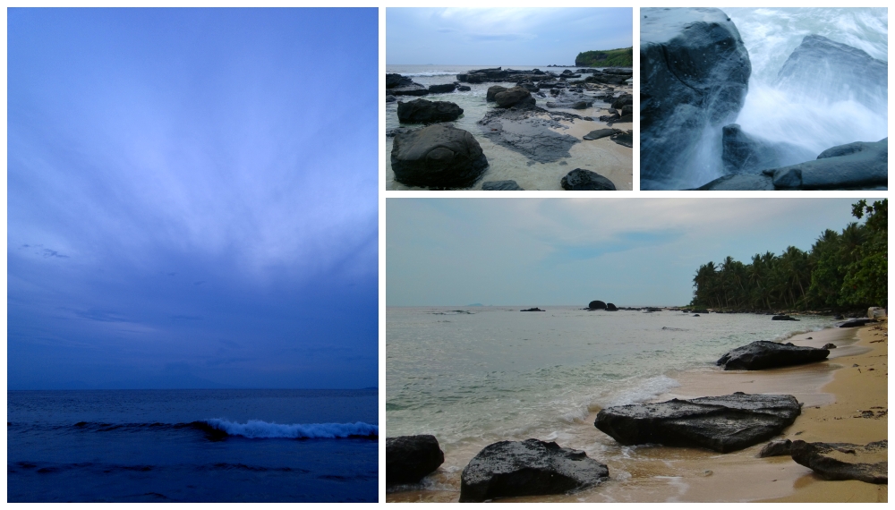
BIRI, Northern Samar - From above, the rock formations look just like ordinary islets but from the ground, these geological features are one of the most magnificent natural wonders you will ever see in the Philippines.

After thousands or even millions of years of constant beating by the Pacific Ocean, sections of the landmass has eroded, separating these six massive rock formations from the main island. Though not as famous as their distant cousin in Ilocos Norte, the Kapurpurawan Rock Formation, Biri's rock formations (namely Magasang, Magsapad, Macadlaw, Puhunan, Bel-at and Caranas) are slowly gaining popularity.

None of the six is similar. In fact, each of them has its own distinct and dominant feature. Read through our separate post for each of the Biri Rock Formations:

• Magasang Rock Formation (visited August 1, 2011)
• Magsapad Rock Formation (visited August 1, 2011)
• Macadlaw Rock Formation (not yet visited)
• Puhunan Rock Formation (not yet visited)
• Bel-at Rock Formation (visited August 2, 2011)
• Caranas Rock Formation (visited August 2, 2011)

Kamuntaha a Local Delicacy in Biri, Northern Samar


Kamuntaha, or mantis shrimp in English, is neither shrimp nor lobster, and definitely not a mantis. This crustacean is a delicacy in the island municipality of Biri, Northern Samar province, and typically cooked by Birianons by boiling them in Sprite with garlic. This simple dish is usually reserved for special occasions such as birthdays and baptisms.

Biri: Punta Beach


Punta Beach is located on the north-western side of Biri Island, the area called Sitio Punta. Its is about 10 minutes from the town proper by motorbike plus another 10 minutes by foot. The beach has mocha colored sand with boulders of limestone scattered around. According to our habal-habal driver and guide, the locals would typically celebrate special occations on the beach with grilled fish and beer.

See complete photo album: Biri, N. Samar: Punta Beach Afternoon (July 31, 2011)

Biri: Google Map Maker

image source: Google Map Maker

Armed with my mobile phone with GPS Track Recorder application, I roamed around Biri's town proper to finally map Biri's roads and main points of interest. The following are my contibutions to Google Map Maker:

Local Roads
San Vicente Street
Salvacion Street
San Roque Street
San Isidro Street
Delos Reyes Street
Luna Street
Tubelleza Street
Dadia Street
Araojo Street
Dorado Street
Coastal Road

Features
Biri Municipal Hall
Biri Port
Biri Police Station
Biri Shrine
Biri Central Elementary School
Biri Municipal Auditorium
Villa Amor

Most importantly, I labeled each of the six (6) rock formations found on Biri, collectivly known as the Biri Rock Formations:

Geography
Magasang Rock Formation
Magsapad Rock Formation
Macadlaw Rock Formation
Puhunan Rock Formation
Bel-at Rock Formation
Caranas Rock Formation

Biri: Villa Amor


Our pumpboat ride from Lavezares ended at Barangay Sto. NiƱo, Biri Island, from where we took a habal-habal (a modified motorcycle that can carry more than two passengers) to bring us to Barangay Poblacion (the municipal capital of Biri). Along the way, we asked our habal-habal driver which resort he could recommend. He immediately replied "Sa Villa Amor, maganda dun." (Villa Amor is a nice one).

The Place
Villa Amor is owned by a Filipina-Australian couple and is the only sea-side resort on Biri Island. It has three fan rooms and one air-conditioned cottage room. They have a spacious lawn where you can enjoy your meals or drinks while admiring the San Bernardino Strait.

Electricity on Biri Island runs for only 12 hours (12:00 noon to 12:00 midnight). This shouldn't be a huge cause of concern. Being a sea-side resort, there is abundance of sea breeze. Just open your room windows and you will surely have a goodnight sleep. We stayed in one of the three fan rooms, the one on the left right next to the patio facing the sea. If you choose to stay in the aircon cottage room, the resort has a power generator that run the aircon at night, though there will be an extra charge for the generator's fuel.

The Rates
Fan Room: PHP600.00 per night
Aircon Room: PHP1,200.00 per night

The Food
The resort doesn't have a restaurant, but the resort staff can cook your meals at a minimal charge of PHP150.00-200.00 per meal (rice & viand) depending on how small or big your group is. They have a small convenience store where you can buy rice and canned goods. You can also walk to the market to buy fresh fish. Just tell the resort staff how you want your food cooked and what time you will eat. Chicken and pork are quite expensive on Biri Island.

Contact Details
+639056804699


See complete photo album: Biri, N. Samar: Villa Amor (July 31-August 2, 2011)

Like them on Facebook: Villa Amor

Lavezares: Jeepney Ride from Catarman


The Ride
From Catarman Airport, we hired a tricycle (Php100.00) to bring us to Catarman town proper where we could take a jeepney then going to Allen, a town located on the extreme west side of the province of Northern Samar. These jeepneys pass through the town of Lavezares, our destination. On the way from the airport going to the town proper, we came across a half-filled jeepney bound for Allen. Our tricycle driver gave a sign to the jeepney driver to stop so we could transfer to the jeep. The fare was Php60.00 per passenger and the duration of the trip was one and a half (1.5) hours. The jeep would stop to pick-up or drop-off passengers.We got-off at the Lavezares town center, in front of the municipal hall and police station.

The Road
Allen-Catarman Road is in very good condition and is surprisingly better than most roads in Metro Manila. It is well maintained and there was hardly any potholes. The 46km road connects Northern Samar's provincial capital, Catarman, to its western port town of Allen.

The People
Each passenger tells a different story: a woman catching a ferry at the port of Allen, men going to work, merchants transporting their goods, a teenager visiting a friend in a neighboring town, and tourists heading to Biri Island (that would be me). One scene that grabbed my attention was a mother traveling with her child (see image above). It reminded me of my childhood when my mother used to bring me with her whenever she would travel to neighboring towns.

The Destination
Lavezares is a town located on the north-western side of the province of Northern Samar. It is the jump-off point to Biri Island.

Manila to Catarman Flight via Cebu Pacific Flight 5J 711

Seven hours after we arrived in Manila from Iloilo, we were back again at NAIA Terminal 3, this time for a flight to Catarman, capital of the province of Northern Samar.

It was the height of TS Kabayan and we were already expecting that our flight would be cancelled. Despite the heavy rain that morning, we were called to board the aircraft at 5:30am. We were already losing hope, and thought that this trip would just go to waste.

There was no sign of the weather condition getting any better, the rainfall even got heavier as we boarded the plane. When we took off, we told ourselves, "there is no turning back now," while staring at the thick rainclouds outside the window.